Settle to Catrigg Force Circular
Walk 4:
Settle to Catrigg Force Circular. By train bus or car. 8 miles. 4.5 hours
- a family walk full of interest taking the highlights of Attermire Scar,
Victoria Cave, Catrigg Force Waterfall, Stainforth and the Hoffman Kiln
at Langcliffe. Some impressive limestone
scenery and the gateway to the Settle Carlisle Railway giving excellent
transport links.![]()
![]() Back
to Settle and Malham
Back
to Settle and Malham
 |
 |
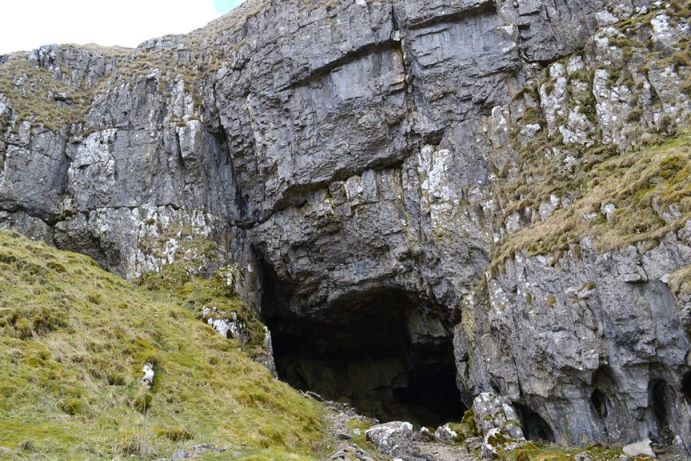
| Victoria Cave | Catrigg Force |
From Settle Station proceed turn right and then left into the Market Place. Bear left at the rear of the market place to proceed up Castleberg Hill. After a short while the bridle way bears right into a walled track climbing steeply uphill. After a small ruined building and gate bear right to go steeply up the grassy slope. On reaching the top with the limestone scar on the left pass through a wall. The scenery starts to become impressive with Warrendale Knotts coming into view. Proceeding slightly down hill cross another wall and then a stile. After the stile turn left climbing uphill between the scars. The path bears right passing through a wall and as it levels out Victoria Cave can be reached on the right by making a slight detour from the main path. Take care around the entrance to the cave as there is a risk of falling rocks. Continue along the path through a further two stiles. Cross a track and then proceeding below the limestone crags through another gate to arrive at the minor road to Malham. Turn right along the minor road for 100m or so and then left over a cattle grid along the access road to Winskill.

On reaching Winskill bear right along a track with the wall on the left. This eventually curves round to the left to pass through a gate with a footpath sign. Follow the track downhill. On reaching the stream turn left to pass through a gate. Immediately turn right at the sign along the dead end footpath to Catrigg Force. This proceeds downhill through a gate and passing through the trees the waterfall will appear in a natural ampitheatre. This is an impressive sight and must rate as one of the best waterfalls in the Yorkshire Dales.
 |
 |
| The track up to Attermire Scar | Warrendale Knotts |
Retrace steps to the gate and the sign post now turning right down the stoney track to Stainforth emerging at the green. After visiting the stepping stones pass back through the green and bear right to reach the river bank for the short walk to the bridge and the Craven Heifer for refreshment.
From the pub continue through the village to reach the main road. After 100m take the footpath to the left at a footpath sign crossing four fields in quick succession. The path then emerges at the boundary of the former Craven Limestone Works a relic of the industrial revolution. There is a waymarked trail around the lime works the centre piece being the Hoffman Kiln, the largest of its kind in the country. It is possible to gain safe access into the kiln passing through one of the many openings. Whilst there is some natural light through the doorways a torch would assist. Once inside the impression is almost monastic. Information boards describe the process.
 |
 |
| Hoffman Kiln, Langcliffe |
After a tour around the site which includes the remains of two other kilns continue along the access road but keeping to the left hand side of the railway line.
Follow the track which then crosses several fields and stile to arrive at the village of Langcliffe. From the green follow the road to Malham Tarn passing to the rear of the church. After a very short while bear right to proceed steeply uphill to reach a gate at the top. Turn sharp right. Now following the same contour pass through two gates to reach the enclosed track [visited earlier] and progress back into Settle and the Market Square.
Pubs and Cafes:- Settle is well catered for with Pubs and cafes
- Talbot Hotel
- Lion
- Bar 13
- Royal Oak
- Settle Down Cafe
- Naked Man Cafe
 |
 |
 |
 |
| Settle |
Important note:- Whilst the author has taken every care in assembling the information on this site, no responsibility can be accepted for any error or omission herein. If in any doubt walkers should consult the relevant OS map.
This page was last updated on 13-May-2020
© John Carey 2015
Upper Wharfedale Lower Wharfedale Ribblehead Nidderdale Malhamdale Middleton Fells Swaledale Ilkley Moor Washburn Valley Coverdale Moorcock Wensleydale